H.J. Andrews Experimental Forest (Lookout Creek) Experimental Watersheds
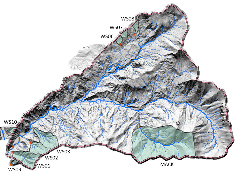
There are nine small experimental watersheds and ten gaging stations on the H.J. Andrews Experimental Forest, including the station near the mouth of Lookout Creek. All gaging stations record stream flow, water conductivity, and water and above-stream air temperature continuously. Most stations also collect water samples proportional to steam flow, which are composited at three-week intervals for chemical analysis. At five of the small watersheds an annual survey of sediment basins provides data on bedload accumulation. The experimental watersheds have also been sampled for vegetation, soils and other data needed to understand hydrological and ecological processes.
| Watershed | Gaged Area (ha) | Gage Elev (m) | Max Elev (m) | Management History* | Stream gage start | Stream chemistry start |
|---|---|---|---|---|---|---|
| 1 | 96 | 439 | 1027 | 100% clearcut 1962-66; burned 1967; no roads | 1952 | 2003 |
| 2 | 60 | 545 | 1079 | Reference, no harvest | 1952 | 1981 |
| 3 | 101 | 476 | 1080 | 25% patch clearcut 1963; 6% roads 1959 | 1952 | -- |
| 6 | 13 | 878 | 1029 | 100% clearcut 1974; 9% roads | 1963 | 1971 - 1987; Restart 2002 |
| 7 | 15.4 | 918 | 1102 | 60% overstory harvest 1974; remaining canopy removed 1984; 12% non-commercial thin 2001 | 1963-1987; Restart 1995 | 1971 - 1987; Restart 2002 |
| 8 | 21.4 | 962 | 1182 | Reference, no harvest | 1963 | 1971 |
| 9 | 8.5 | 426 | 731 | Reference, no harvest | 1968 | 1968 |
| 10 | 10.2 | 461 | 679 | 100% clearcut 1975 | 1968 | 1968 |
| Mack | 580 | 755 | 1626 | 13% harvest; road on ridgeline | 1979 | 1980 |
| Lookout | 6242 | 422 | 1627 | 25% harvest 1952-1985; 10% roads | 1949 | 2005 |
* The centuries-long fire histories of watersheds are complex and only partially reconstructed from tree ring records. 70% of Lookout Creek watershed burned in fires in 2020 and 2023, including 100% of WS 1, 9, Mack and ca. 50% of WS2. See the detailed watershed histories document for summaries of fire and forest management information.
Detailed Histories
For a complete, compilation watershed histories relating to stream gage descriptions and instrumentation in gaged watersheds at the HJ Andrews Experimental Forest, 1949 to present, see Gaged watersheds descriptions and instrumentation. Or, view each watershed individually using the links below (these links will take you into our database pages).
Andrews Lookout Creek Watershed
Real-Time Data
Provisional, real-time, streaming data are available for most gauging stations. See our Real-time Data pages.
Primary Studies
HF004 - Stream discharge in gaged watersheds at the Andrews Experimental Forest, 1949 to present
HT004 - Stream and air temperature data from stream gauges and stream confluences in the Andrews Experimental Forest, 1950 to present
HS004 - Annual bedload accumulation from sediment basin surveys in small gauged watersheds in the Andrews Experimental Forest, 1957 to present
CF002 - Stream chemistry concentrations and fluxes using proportional sampling in the Andrews Experimental Forest, 1968 to present
CF012 - Stream specific conductance and temperature from small watersheds in the Andrews Forest
CP002 - Precipitation and dry deposition chemistry concentrations and fluxes, Andrews Experimental Forest, 1969 to present
GS002 - Stream cross-section profiles in the Andrews Experimental Forest and Hagan Block RNA 1978 to present